 |
| Using this FOX10 photo, we have been able it better identify the location of the wrong-way crash. Scroll through post. |
We're signing off now and this is our final comment. Remember that "Just Another Day on I-17" has a whole new meaning, right? Good Night & Many Cheers, jp)
(Editor's Note: An updated ABC15 News report updated about 2:30 PM indicates that the collision may not have been fatal, contrary to earlier report. See excerpt at end of this post with source link.)
A carjacking. Shots fired at DPS Officers. A high speed chase. A wrong way driver. A head on collision. That's the general outline of what we know about today's dramatic events on I-17.
As of 10:30 AM, the southbound lanes of I-17 were closed and would not reopen for many hours. Meanwhile, as everyone knows, "Southbound Sunday" turned into a classic I-17 nightmare. Traffic that hasn't already been caught in the closure has been diverted to either 89A or a really, really long detour to Highways 87 and 260.
Meanwhile, ADOT said traffic backed up 7-8 miles on 89A north of Sedona. That distance is well north of Slide Rock State Park.
This blog post will be evolving over the next few hours until the southbound lanes reopen. We will attempt to find out as much as possible about the events leading up to the crash that closed the highway. Details are few and far between. We will attempt to "source" each of our updates. Your best source of accurate, up-to-the-minute information is the ADOT Twitter account:
At 1:54 PM, DPS Tweeted these photos and said, "Our detectives, troopers & Yavapai Co. deputies are investigating two crime scenes southbound along #I17 between Munds Park & Camp Verde. (Source: https://twitter.com/Arizona_DPS)


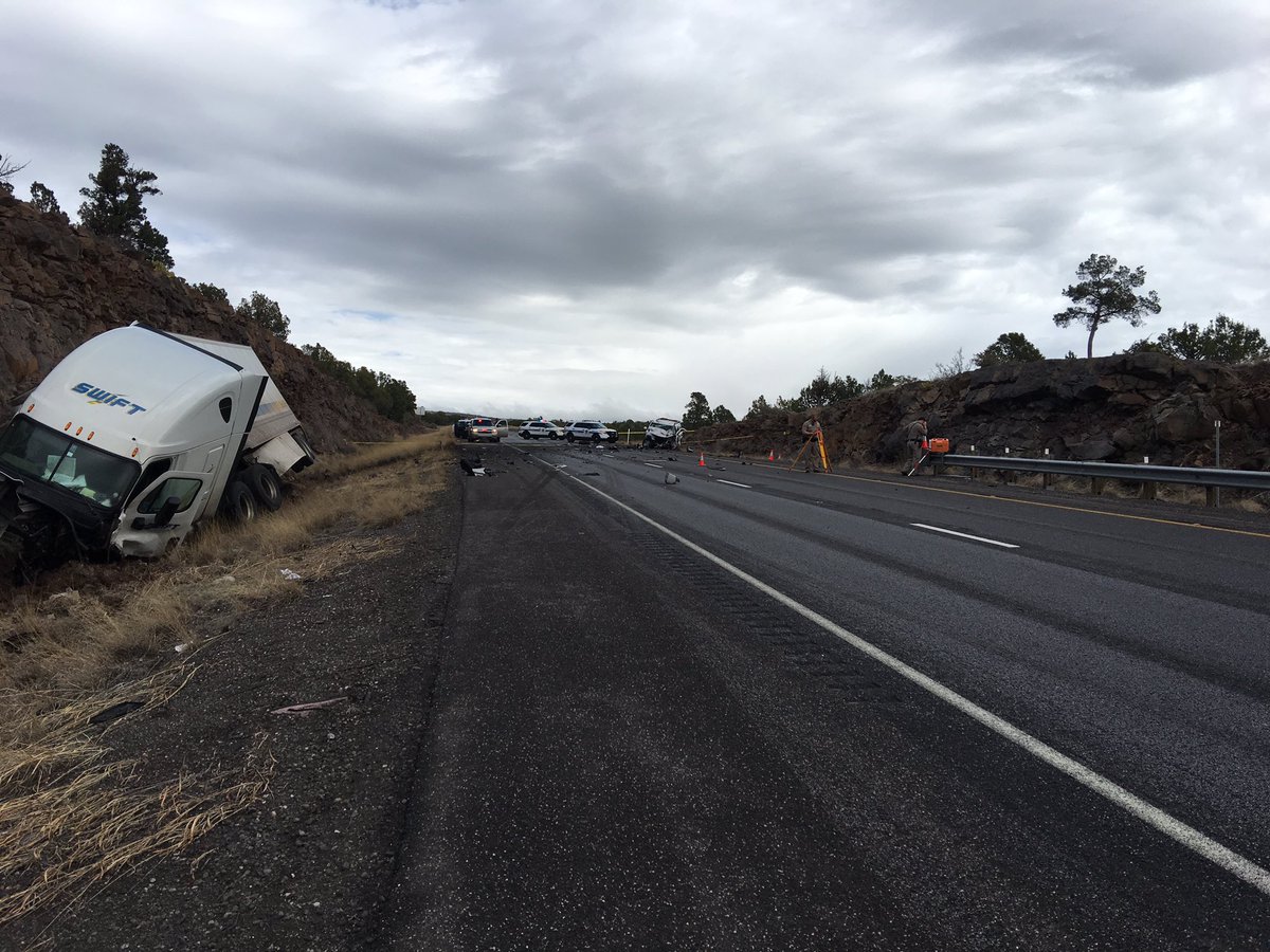
Confusion exists as to the exact location of the crash. Some reports indicated Milepost 308 or 307 and some say Milepost 317. We're certain the crash took place near Milepost 307 for several reasons: 1) AZ DPS Col. Frank Milstead uses MP 307 in his Tweets; 2) The FOX10 photo at the top of this post shows the crash in an area that we personally well know; and 3) Milepost 307 is one mile north of the Stoneman Lake Road exit and the vegetation is a pinon-juniper forest. At Milepost 317, the vegetation is a Ponderosa Pine forest. Meanwhile I-17 is closed at Milepost 317 which is the Munds Park exit. That's probably how the confusion arose about the location of the crash.
It is clear that the southbound lanes will be closed for an extended period while officials investigate, document, record and clear the scene.
The story apparently began about 9 AM Sunday and we are working to find and list sources about the earlier events.
The first Tweet that we can find about today's event is time stamped 9:18 AM.
 A subsequent identical Tweet from Col. Milstead's account is time-stamped 10:18 AM. Meanwhile, the most recent Tweet from Col. Milstead's account is time-stamped 10:35 and indicates there was a "fatal collision".
 Meanwhile, limited alternate routes are available to avoid the southbound snarl. Traffic is backed up for many miles in Oak Creek Canyon, possibly as far north as nearly to Slide Rock State Park. As everyone knows Southbound Sundays are typically the busiest and most congested on I-17 between Flagstaff and The Valley. Most of the visitors to The High Country are returning home on Sunday afternoon.

Most credible reports indicate the crash too place at Milepost 307. The FOX10 photo at the top of this post shows an area with which we are very familiar that is located perhaps 150-200 yard north of where I-17 crosses Rattlesnake Canyon about a mile north of the Stoneman Lake Road exit. Rattlesnake is a tributary of Woods Canyon which then becomes Dry Beaver Creek when it flows under Highway 179 between I-17 and the Village of Oak Creek.
ABC15 News has this report updated at about 2:30 PM. http://www.abc15.com/news/region-northern-az/flagstaff/i-17-closed-southbound-near-munds-park-for-deadly-crash-and-shooting-involving-carjacking-suspect
 Below is just a mere glimpse of the standstill snarl at Munds Park and points north. Photo credit: Mike Schmidt, 3TV/CBS 5

Drivers and passengers stuck in this snarl need to remind themselves that what happened isn't "just a crash". Nope. It's a "Crime Scene" and there are huge differences in how DPS Officers are required to handle a normal crash versus a crime scene.
We're getting a little bit better idea of the timing of this incident. The AZFAMILY article linked here indicates the carjacking probably took place AFTER 10 AM since reports of reckless driving were coming in before 10 AM as per the article. The news report states, "Authorities said they began getting reports of a vehicle driving recklessly southbound along I-17 north of Camp Verde just before 10 a.m." The head on crash is said to have taken place "around 10:20 AM". http://www.azfamily.com/story/34484727/dps-carjacking-suspect-fires-at-troopers-ends-in-fatal-crash Flag Scanner copied and posted an MP3 audio file of the Dispatcher's communication during the chase and crash. It appears the Mustang was driven south on I-17 to around around Milepost 291 and then North in the correct lanes to Stoneman Lake Road. It was here that the Mustang then crossed into the Southbound lanes. Scrolll through Flag scanner's post until you see the link shown by the arrow in the screen clip below. Get some headphones. https://www.facebook.com/photo.php?fbid=754752111354724&set=a.100448770118398.974.100004598250156&type=3
 Here's a copy of the ADOT Tweet announcing the road reopening. Notice the time stamp of 8:10 PM.


ABC15 News has this report updated at about 2:30 PM. http://www.abc15.com/news/region-northern-az/flagstaff/i-17-closed-southbound-near-munds-park-for-deadly-crash-and-shooting-involving-carjacking-suspect
"DPS says there were reports of a red Mustang driving recklessly southbound on I-17 north of Camp Verde just before 10 a.m. The car crashed with a vehicle, and the driver of the Mustang got out and took a white GMC SUV from the crash scene at the point of a rifle.
The suspect fired at troopers pursuing the stolen SUV, DPS said, but no one was injured by the gunshots.
The stolen SUV crashed head-on into a semi in the southbound lanes of I-17 about 15 miles south of Munds Park, according to a DPS spokesperson.
The suspect was airlifted from the scene with life-threatening injuries. DPS said the suspect remained alive as of Sunday afternoon, correcting earlier information provided by Col. Frank Milstead that the suspect had died in the crash.
The driver of the semi was not severely hurt, DPS said.
According to Col. Milstead, no troopers were injured in the incident."
The confusion about the Milepost of the crash may have come from media use of the Milepost of the actual closure of I-17. I-17 is closed at Milepost 317 which is the Munds Park exit. Apparently, semi-trucks either can't or have chosen not to turn around at that exit so they are backed up alongside I-17.
We just received a report from a Dear Friend we trust 100%. She was returning from Sedona to Rimrock via I-17 shortly after 1 PM. After getting on I-17 at the Sedona exit, she passed police activity in the Southbound lanes at a point north of the McGuireville Rest Area. She reported seeing a red Mustang with a crashed front and a truck showing rear collision damage.
This would be consistent with the DPS report about investigating two crime scenes on I-17 Southbound. Based on information gleaned from the ABC15 report, this may have been the point where the carjacking took place.
It remains to be revealed what happened after the Tahoe was carjacked. Did it travel south and then turn around? Or did it go north in the southbound lanes from the point of carjacking? Where were the shots fired at DPS Officers? Many questions remain.
The ABC15 News reports attributes DPS as saying, "the driver of the Mustang got out and took a white GMC SUV from the crash scene at the point of a rifle."
Note that in the FOX10 News photo, a DPS Officer is carrying two AR-15 rifles away from the crashed GMC SUV. Was one of these rifles used in the carjacking?
Typically DPS will issue most known facts of an incident within 24 hours of its occurrence. We will add official information when it is released.
The confusion about the Milepost of the crash may have come from media use of the Milepost of the actual closure of I-17. I-17 is closed at Milepost 317 which is the Munds Park exit. Apparently, semi-trucks either can't or have chosen not to turn around at that exit so they are backed up alongside I-17.
This would be consistent with the DPS report about investigating two crime scenes on I-17 Southbound. Based on information gleaned from the ABC15 report, this may have been the point where the carjacking took place.
It remains to be revealed what happened after the Tahoe was carjacked. Did it travel south and then turn around? Or did it go north in the southbound lanes from the point of carjacking? Where were the shots fired at DPS Officers? Many questions remain.
The ABC15 News reports attributes DPS as saying, "the driver of the Mustang got out and took a white GMC SUV from the crash scene at the point of a rifle."
Note that in the FOX10 News photo, a DPS Officer is carrying two AR-15 rifles away from the crashed GMC SUV. Was one of these rifles used in the carjacking?
Typically DPS will issue most known facts of an incident within 24 hours of its occurrence. We will add official information when it is released.


Drivers and passengers stuck in this snarl need to remind themselves that what happened isn't "just a crash". Nope. It's a "Crime Scene" and there are huge differences in how DPS Officers are required to handle a normal crash versus a crime scene.
We're getting a little bit better idea of the timing of this incident. The AZFAMILY article linked here indicates the carjacking probably took place AFTER 10 AM since reports of reckless driving were coming in before 10 AM as per the article. The news report states, "Authorities said they began getting reports of a vehicle driving recklessly southbound along I-17 north of Camp Verde just before 10 a.m." The head on crash is said to have taken place "around 10:20 AM". http://www.azfamily.com/story/34484727/dps-carjacking-suspect-fires-at-troopers-ends-in-fatal-crash Flag Scanner copied and posted an MP3 audio file of the Dispatcher's communication during the chase and crash. It appears the Mustang was driven south on I-17 to around around Milepost 291 and then North in the correct lanes to Stoneman Lake Road. It was here that the Mustang then crossed into the Southbound lanes. Scrolll through Flag scanner's post until you see the link shown by the arrow in the screen clip below. Get some headphones. https://www.facebook.com/photo.php?fbid=754752111354724&set=a.100448770118398.974.100004598250156&type=3


